
Hurricanes in Water Mill
Water Mill — a Long Island community sticking out into the Atlantic — has always been vulnerable to hurricanes. They were known locally as equinox storms because they often occurred around the time of the autumn equinox on September 22. It was not until the mid-20th century that the storms were called by the Carib Indian word “hurricane.”
Early Storms
Daniel Hildreth of Seven Ponds Road, in an entry in his diary, wrote about the September 20, 1815 storm:
“The sea rose so high it swept down almost every bank the length of the island. The bay rose so high it ran up in the Mill Pond. It drove sand into ponds & creeks and buried valuable land & meadows.”
There were other powerful hurricanes between 1821 and 1869, followed by a 69-year lull before a devastating storm struck eastern Long Island on September 21, 1938.
The Hurricane of 1938
At that time, the beach and Mecox Bay were not as extensively developed as they are today. There were only two summer houses, some fishing shanties and a beach club building on the Water Mill beach. Mecox Bay was flanked on three sides by open fields.
From experience, farm families knew enough about ocean storms to locate their homes away from Mecox Bay. A few summer homes were located on high ground at the northern end of Mecox Bay along Hayground Cove and Mill Creek.
The 1938 storm arrived at high tide, and strong winds created a 15-foot storm surge. The wall of water traveled north across Mecox Bay, up Mill Creek and pushed the creek north into Mill Pond. The water in Mill Creek rose as high as the main floor of the water mill, now the Water Mill Museum.
One of the two summer houses on the beach was destroyed, all the fishing huts were demolished, and the beach club was leveled, with its debris washing across Mecox into the fields at Mohawk Avenue. The Cobb Isle and Channel Pond bridges were dislocated and floated into the bay.
Many of the farm fields around Mecox were either flooded with salt water or had their crops washed out by heavy rains. Previously, Dune Road/Flying Point Road had dunes 40 to 75 feet high, but the storm surge flattened them and washed much of the sand into Mecox Bay.
Damage Across Water Mill
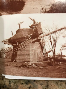
Although no homes inland were completely destroyed, many were damaged by fallen trees or winds that ripped off roofs and knocked over chimneys. Small farm buildings were blown across the fields. The belfry of the Water Mill School was destroyed, the cap of the Corwith Windmill was blown off, and the railroad tracks at Scuttle Hole Road washed out. Fallen trees blocked the main roads.
Although 29 people died in surrounding communities and more than 500 in New England, there was fortunately no loss of life in Water Mill.
Hurricanes After 1938
There have been nearly a dozen hurricanes since 1938 that have caused crop damage, toppled trees and damaged buildings. Most of these storms were classified as minimal or moderate, with winds or gusts between 75 and 95 miles per hour. The last significant storm noted in this account was Hurricane Gloria in 1985.
The historical account anticipated that a Category 2 or 3 hurricane, with winds of up to 115 miles per hour, could strike eastern Long Island and cause more extensive structural damage because of increased development along the ocean and in the flood plains surrounding Mecox Bay.
For more information about hurricanes and a firsthand account of the 1938 hurricane in Water Mill, consult Water Mill Celebrating Community: The History of a Long Island Hamlet, 1644–1994. The book is available at the Rogers Memorial Library or may be purchased at the Water Mill Museum.